I reported that Paradise would open late this winter and that prediction is spreading. The News Tribune now says March... They also increased the estimated cost to date: $791 K. As noted earlier, the repairs at mileposts 5 and 9 will each take a minimum of 1-2 months The question is, can those repairs take place concurrently? I also wonder about the difficulty of doing such work in the middle of Mt Rainier's winter. Dare we say...???
Over the next few months, there will be a number of events around the Puget Sound (and maybe beyond) to raise awareness to Mt. Rainier's flood and recovery work. They are a great opportunity to reconnect with the park and discuss what's happening on the mountain. My first scheduled talk/show is on Jan. 19th at the Mountaineers Clubhouse in Tacoma. I'll put more information up about the program when the details settle.
The suggestion to access the mountain from Highway 410 was well intended, but we've since learned that the state doesn't allow any parking along HWY 410 near the park boundary. You either have to have someone drop you off, or [READER CONTRIBUTED UPDATE] park in the small pullout on the right, which isn't always plowed, as you turn onto Crystal Mountain Blvd.
Speaking of intrepid climbers, a few showed up at Nisqually Entrance wanting to hike the Nisqually Road to Paradise. The road corridor, however, remains closed. There is some talk of allowing access to the westside road or Longmire, but those issues are still up in the air and largely depend upon the repairs at Sunshine Point and Kautz Creek. Stay tuned.
Monday, December 11, 2006

Sunday, December 3, 2006
Pristine, Pink, Breathless
 That's what it was like on the mountain this weekend. I made it to Camp Muir Saturday, my first opportunity in over two months. Finally, time to survey the camp and search for possible storm damage (and test the snow conditions on the Muir Snowfield).
 Things looked normal for early December. There was access to the public shelter, but the toilets were drifted in with deep snow. As for obvious signs of rain and wind damage, it seems that only the NPS suffered. We lost two storage boxes. The weather telemetry equipment for the NWAC appears to be working. It's my hope that once the power resumes at Paradise, the weather data will come back up online.
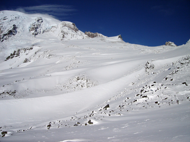 I was a bit surprised that there wasn't more snow cover between 7-11k. Everything looked wind scoured, i.e, lots of exposed rocks along the eastern edge of the Muir Snowfield, Cowlitz Cleaver, Muir Rock, etc. As for the upper mountain, the Nisqually Glacier looked very, very good. And while we're talking, so did the Nisqually Cleaver and Gib Ledges. Plenty of snow and ice in those rocky steep sections
 After surveying the camp, it was time to confirm the conditions on the Muir Snowfield. And it was just as I thought it would be: 4,500 feet of untracked packed powder, with a few rocky areas around McClure. As you can see, the mountain turned pink for our descent. Top photo by Ethan McKinley
JUST IN: The Camp Muir and Paradise weather telemetry data are back up. I hope they last! I know that they ran the generator at Paradise today.
Friday, December 1, 2006
691K
When I said it was going to be tough to climb Mt. Rainier again in 2006, it wasn't meant to deter any ambitious climbers. In fact, for those motivated enough, the summit is still available. It's just that you're going to have to start at a lower elevation and hike a lot further. The best access is probably at the Highway 410 closure near the Crystal Mountain turnoff. But if you were REALLY determined and wanted to say, climb Liberty Ridge, you could start at the Carbon River entrance. Either way, please make sure that you self register when you go. And if you'd like, write me for the latest gossip on road access.
As for public access to Paradise, it's still going to take a while based on the conservative estimates prepared by the federal highway engineers. The main obstacles are at mile makers 5.2 and 9.1. In both areas, the road is compromised by landslides, that will take two months (minimum) to stabilize and/or reroute around.
And the infamous Kautz Creek stream jump??? (Remember, the creek flows over the road) Superintendent Dave Uberuaga elected to have NPS crews raise the road bed and install more culverts. The other option kicked around involved a large bulldozer and over 1 mile of chainsaw work and cat tracks into the wilderness. That plan called for diverting the stream back into its original channel. A bulldozer partially explored this option early on, but a number of wilderness advocates expressed concern over the invasive procedure and it was put to rest. Regardless, the Kautz Creek recovery is closer to completion than the other repairs listed above.
And while we're discussing repairs, I was informed today that the park has spent over $691,000 on flood response and recovery, and the job is far from done! In Longmire, we're relying on generator power which means that our sewer system is still down... Though decisions and progress are being made, the road to full recovery is a ways off. I did hear one really reassuring comment from the Deputy Superintendent Randy King. He said "we intend to repair all the roads, all of the facilities, all of the trails damaged by this storm." In essence, the park is doing all that it can to be fully functional for next spring and summer.
As for public access to Paradise, it's still going to take a while based on the conservative estimates prepared by the federal highway engineers. The main obstacles are at mile makers 5.2 and 9.1. In both areas, the road is compromised by landslides, that will take two months (minimum) to stabilize and/or reroute around.
And the infamous Kautz Creek stream jump??? (Remember, the creek flows over the road) Superintendent Dave Uberuaga elected to have NPS crews raise the road bed and install more culverts. The other option kicked around involved a large bulldozer and over 1 mile of chainsaw work and cat tracks into the wilderness. That plan called for diverting the stream back into its original channel. A bulldozer partially explored this option early on, but a number of wilderness advocates expressed concern over the invasive procedure and it was put to rest. Regardless, the Kautz Creek recovery is closer to completion than the other repairs listed above.
And while we're discussing repairs, I was informed today that the park has spent over $691,000 on flood response and recovery, and the job is far from done! In Longmire, we're relying on generator power which means that our sewer system is still down... Though decisions and progress are being made, the road to full recovery is a ways off. I did hear one really reassuring comment from the Deputy Superintendent Randy King. He said "we intend to repair all the roads, all of the facilities, all of the trails damaged by this storm." In essence, the park is doing all that it can to be fully functional for next spring and summer.
Subscribe to:
Posts (Atom)


